New Holland’s position upon the globe
One of the thought-provoking themes included in the latest exhibition in the Noel Shaw Gallery, Plotting the island: dreams, discovery and disaster, is the Dutch encounter with Australia in the 17th century. The Dutch are viewed as having added the coastline of Australia to the world’s map through their landings on the continent from 1606 until 1644 and their subsequent issuing of printed maps. For example, the world map reissued by Daniel Stopendael shows New Holland’s position on the globe, yet its outline is incomplete and inaccurate and there was and is still much to learn about its bounds and character.

It was the lucrative spice trade that brought the Dutch to establish their (VOC) trading port in Batavia (now Jakarta) and on to Australia, sometimes purposefully, other times by fateful accident. Early landings encountered inhospitable shores and then in 1629 the ship Batavia lost course and was wrecked on the Houtman Abrolhos islands off the coast of Western Australia. The astounding mutiny and massacre that transpired amongst the survivors is a grisly chapter of Australian history. [1.] Melchisédech Thévenot’s book, Relations de divers voyages curieux … (Account of diverse and curious voyages) (1663-1672), compiles many travel stories, including the harrowing shipwreck of Batavia. It also features an important map of New Holland showing its outline as it was understood in 1644. Sections of this coastline, which incorporates Tasmania and New Zealand, were charted by Abel Tasman (1603-1659) during two separate voyages in 1642 and 1644. This map was published in three states (versions) and the Baillieu’s copy has the addition of a wind rose at right. [2.] As Martin Woods notes in the exhibition catalogue, this map has dual Dutch and French labels, with the unexplored section headed Terra Australis suggesting the way forward for French navigational ambitions. [3.] Yet to the French of the 17th century the South Land was also ‘Gonneville Land’, a utopia of gold.
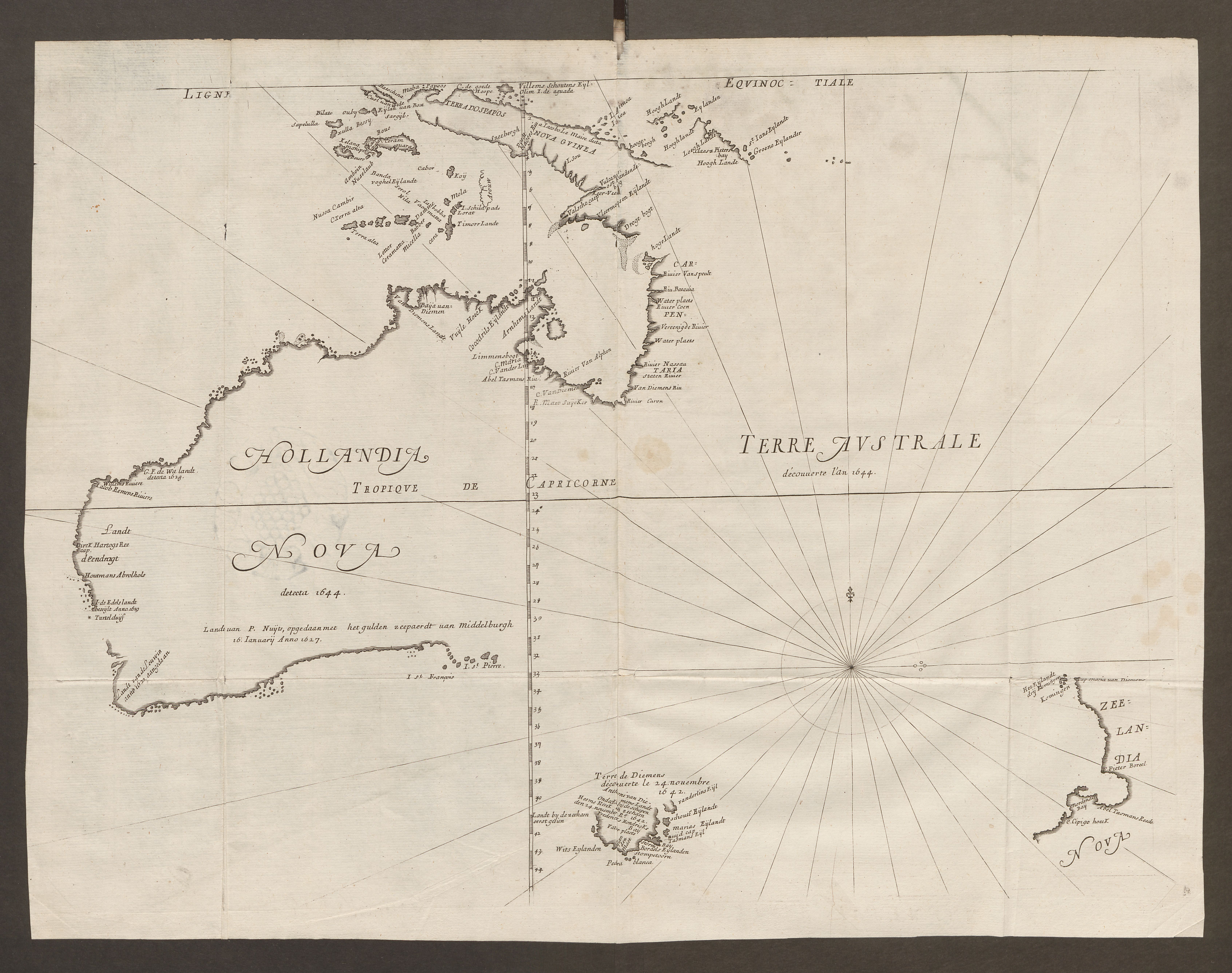
Tasman was commissioned by Anthony Van Diemen, Governor-General of the Dutch East India Company, to explore the Great South Land. The combination of Van Diemen’s death in 1645, savage coasts and unpromising trade prospects saw the Dutch abandon New Holland, and it was not until the 18th century that exploration to the South Land was again continued by the English and the French. Thévenot’s book was a model which inspired Enlightenment writers who followed in the 18th century.
The set of Dutch books De mensch, zoo als hij voorkomt op den bekenden aardbol (Man as he appears on the familiar globe) (1802) is an example produced from Enlightenment ideals. It brings together information from many published sources, with order and classification. It is a book of anthropological geography based on voyages of exploration, locating its subjects in the paradigm of the Noble Savage. Its illustrator Jacques Kuyper (1761–1808) was a director of Amsterdam’s drawing academy and his artistic style was Neoclassical, a hallmark of the Enlightenment. The images are regarded by scholars as derivative to the voyages as they were made in response to them rather than from direct experience, nevertheless they offer rich waters for researchers, particularly so as the Baillieu Library holds the majority of the preparatory drawings for the book, in which can be seen additional information such as inscriptions and differences between the planned images and the printed versions.

The image Niew-Hollanders [3.] is featured in volume three; this text and image draws heavily from the published accounts of Cook and Sydney Parkinson. The position of the image in the third volume is rather unusual as the preceding volume contains South Sea Islanders and includes New Zealanders and Van Diemen Landers (Tasmanians). A result is that Tasmania and mainland Australia have been separated; additionally New Hollanders have been grouped with first-nation peoples of North America including such distant locales as Alaska. It calls to mind those early Dutch experiences with the South Land and the three distinct landmasses and peoples they briefly encountered; at that moment in history Europeans could not have had a well-developed understanding of the relationships and individual complexities of these lands and peoples.
Australia straddles two oceans: the Indian and the Pacific. Each of these regions has quite distinctive environments and customs. So, does it belong with the islands of the East Indies, or the Pacific, or, as it has sometimes been perceived, as an extension of the Americas? While Australia’s coastlines became more defined, its identity is not so readily classified and its position on the globe more than merely its longitude and latitude. For its Indigenous people, and for different citizens of the world, Australia each has different meaning.
Kerrianne Stone (Curator, Prints)

References and further reading
[1.] See the full account in Mike Dash, Batavia’s graveyard, London: Weidenfeld & Nicolson, 2002
[2.] Robert Clancy, The mapping of Terra Australis, Macquarie Park, N.S.W.: Universal Press, 1995 p. 82
[3.] Martin Woods, ‘New Holland dreams and misgivings’ in Plotting the island: dreams, discovery and disaster, University of Melbourne, 2017, p. 28
[4.] The much needed conservation of this drawing was funded by Miegunyah.
Categories
Leave a Reply