Staten Landt: where the Americas meet the Antipodes
Even the most adventurous of traveller would struggle at dead reckoning Staten Landt, despite it being clearly marked on some maps, such as Polus Antarctius (South Pole), one of the featured maps in the Noel Shaw’s current exhibition Plotting the island: dreams, discovery and disaster. Staten Landt is a rather complicated place: changing in size and location on the globe. It appears sometimes as a continent near the Americas, and at others as an island attached to Australia or New Zealand. It is a newly depicted land which seems to have both emerged and became extinct in the course of the 17th century.
Polus Antarcticus was first issued in 1637 by Dutch cartographer and engraver Henricus Hondius. At a time when Europeans had not seen the underside of the globe, this circular projection proved to be so innovative and appealing that it was revised and reprinted over a period of more than 60 years. On display is the original version of the Hondius, published by Jan Jansson. Jansson would later update the coastlines on this map in 1650, after the voyages of Abel Tasman in 1642 and 1644. Tasman’s voyages revealed additions to the coast of New Holland as well as parts of the coasts of both Tasmania and New Zealand, which had to be added to Dutch maps; and the title cartouche on Polus Antarcticus had to be replaced by New Zealand, for example, as the picture of the Antipodes took shape.

Yet there is another coastline on this map: an indistinct line which begins at South America and is hand-coloured green in the University’s map, petering out in the South Seas. This vague and, by the length of it, massive geographical area is Staten Landt.
In the 15th and 16th centuries it was believed that the Great South Land or Terra Australis was joined to the Americas at Tierra del Fuego (Land of Fire). Francis Drake disproved this theory during his circumnavigation between 1577 and 1580. In his wake, the Dutch mariners Jacob Le Maire and Willem Schouten formed the Australische Compagnie (Australian Company), an expedition which sailed in the vessels Eendracht and Hoorn between 1615 and 1617 in search of another route to the lucrative Spice Islands and also the mythical South Land. Both of the expedition’s missions were achieved: a new trade route was indeed found around the Cape of Good Hope, and the Eendracht, captained by Dirk Hartog, landed on Western Australia in 1616, as marked on this and other maps in the exhibition (t’Landt van d’Eendracht). However, en route the expedition paused on the Patagonian coast of South America. This was where the Hoorn was lost to a fire and where Le Maire and Schouten saw a land to their east which they conjectured was part of the South Land; this they named Staten Landt (Country of the Lords of the State).
In 1643 Hendrik Brouwer identified the landmass seen by Le Maire and Schouten as an uninhabited island. Abel Tasman further complicated the matter by declaring the south island of New Zealand as Staten Landt, which he believed to be part of the unknown South Land or Antarctica. So it is not so surprising then, to find Staten Landt tentatively placed on the map between Tierra del Fuego and Antarctica. Polus Antarcticus has the curious effect of showing simultaneously both the landmasses in the Antipodes that the Dutch had mapped in the 17th century, and also a mythical one that they had invented.
When thinking about new lands, thoughts soon turn to the people who might inhabit them. The people depicted on the attractive hand-coloured border are not Antipodean as might be expected of the South Pole. Rather, they are people of the Americas.
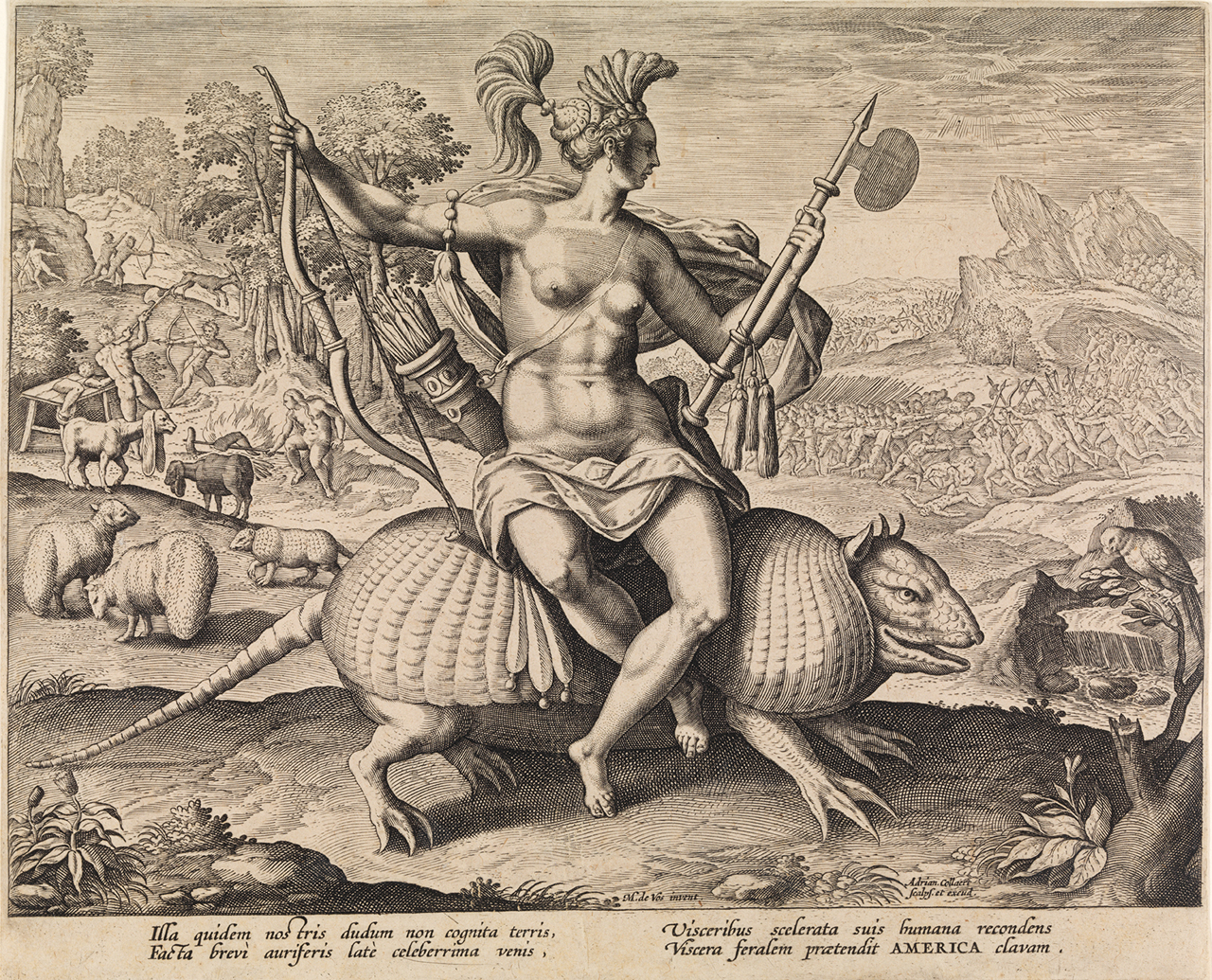
In an earlier Flemish engraving titled America (c.1588), also in the exhibition, a European view of Native American people is seen. An allegorical representation of America is depicted as a woman holding bow, arrow and axe, and riding an armadillo. In the background, at right, the Spanish are at war with the inhabitants, while at left, cannibals prepare a leg on a spit. This disturbing scene of cannibals roasting human limbs lurks frequently enough in the background of New World images to become something of a pictorial trope. The motif is repeated at the top left of Polus Antarcticus, although just what is being cooked over the fire is not apparent. In this document, European printers seem to have let the Americans put aside their gnawed arms and legs to instead hunt penguins, which are depicted in the right margin.
A figure at left is made rather dramatic by the colourist who has chosen to interpret the atmosphere behind him as fire, perhaps a reference to perceived fiery lands like Tierra del Fuego, where these lines could just as likely be wind or sky. As each map was individually coloured, no two are the same, and Polus Antarcticus has been coloured by many different points of view since its publication in 1637.
Polus Antarcticus is an important early record of the mapping of the southern lands. Equally, through Staten Landt and its depiction of people, it is a document representing the meeting of the Americas and the Antipodes.
Kerrianne Stone (Curator, Prints)
Further reading
For explanations of Staten Landt see Robert Clancy, The mapping of Terra Australis, Macquarie Park, N.S.W.: Universal Press, 1995, especially pages 108, 111, 112 and 115.
Categories
Leave a Reply